Last week, I was able to submit the first refereed journal article for my retirement PhD research. Right now we are waiting to see whether it will be accepted and to for the formation of a review committee at the Hydrology and Earth System Sciences (HESS) journal. We think it is a pretty good article about how to create machine learning models with image features from annotated with USGS stage (water level) and discharge (stream flow) sensor measurements to fill gaps in the data when there is equipment or funding failure. We actually got some pretty amazing results. The images were not taken in a way that is normal for scientific or engineering purposes, but from a documentary project (Platte Basin Timelapse project). Here is a graph from an earlier post.
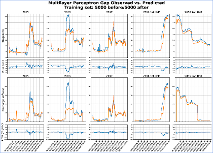
This shows the observed vs. predicted graphs for the data gap filling. The middle (2016) year did not predict so well in the preliminary effort, but we addressed that and made better predictions in the paper.
Leave a Reply