"In the world ye shall have tribulation: but be of good cheer; I have overcome the world." –John 16:33

San Pedro Garza Garcia

Category: WaterEval

Latest cool KOLA image

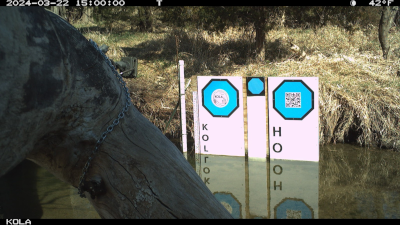
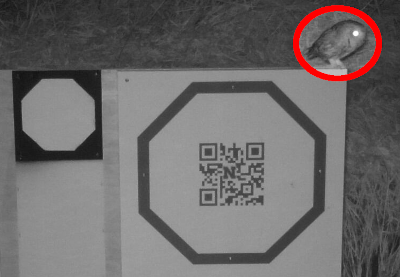
We get lots of cool images from the cameras we use at University of Nebraska for our image-based water level measurement research. This latest one is new for me. My understanding is that it is a screech owl. Honestly, this is the funnest part of the job. Dr. Mary Harner collects all the images with something interesting in them from the Kearney Outdoor Learning Area (KOLA) she manages on Turkey Creek near the high school in Kearney, Nebraska. It truly is amazing what shows up and we feel like we are really getting to know the raccoon family who are some of our most frequent visitors.

Volunteer research update

My PhD adviser, Troy, at University of Nebraska just sent me an image from a new camera he put up for some research we are doing. I actually have quite a few updates about the work I am doing with Troy (and others) since when I graduated. It is still pretty weird to have people calling me Dr. Chapman, but it is also pretty fun. So, I am just going to do this as a list and might fill in details on some of it as things start to happen. Here is what is going on:

  • University of Nebraska-Lincoln is in the process of making me an adjunct professor
  • North Carolina State University (NCSU) is in the process of making me and adjunct professor
  • Our planned next article is a publication with additional data based on the fourth chapter of my dissertation
  • The article after that will be an analysis of how well we do with the very small octagon in the picture above relative to the bigger octagon (I will discus the calibration methods in a future post)
  • I am a committee member for a Bio-Ag Engineering PhD student at NCSU

Applying for adjunct

Even after finishing my PhD at University of Nebraska–Lincoln (UNL), I continue to work there as a volunteer. We have collaborative projects with the ITESM University system in Mexico, a public/private water services company in Australia, University of Nebraska–Kearney, North Carolina State University, and the USGS, with other potential partners on the horizon. My professor, Troy is working to make me an Adjunct Professor at UNL so that I can act as a committee member for appropriate graduate students and have an official, unpaid connection with the university for work I would be doing whether or not they give me that designation. Today, I wrote them a formal letter to request an adjunct professor appointment, so we will see where it goes from here. I continue to work on the GRIME2 software and support the research efforts that use it. It is kind of amazing to us that it continues to attract user and has different applications than what we could have imagined when we wrote the software.

All raccoons all the time

Almost everywhere we put our GaugeCam cameras, raccoons show up. They are amazing little animals. They have been particularly prominent at the KOLA location in Kearney, Nebraska. They are totally fascinating–I get addicted to watching them.

GRIME2 testing in Brisbane

The volunteer Hydrology work I do with University Nebraska-Lincoln is starting to solidify now that I no longer have a formal position at UNL. Last night a researcher in Brisbane, Australia met online to work out the use of the GRIME2 Command Line Interface (CLI) libraries for measurement of water level at what could be over 100 separate locations if we can demonstrate capability. Then today, I met online with a graduate student who we hope will be able to extend the libraries to handle much smaller calibration targets for the purpose of crowd-sourcing imagery and placing small calibration targets at the top of garden variety staff gauges. What is great about this is that these people are starting to adopt and extend the libraries without my involvement other than to provide guidance to get them going and to help them when they get stuck.

Stumbling forward

The retirement PhD project is moving right along. We actually think we have stumbled onto something that might be important. We have had opportunity to work and reflect on what we are doing at a deeper level than might have been possible if we were still living life before the Chinese Corona-virus. We think it has paid off. Today we pretty much came to an agreement on what will be necessary to finish my PhD research. It is a good bit of work, but there is not too much science left because we have already done the heavy lifting in that regard. There is still the significant burden of the taking of classes, passing the prelims, and writing it all up, but that is just work, not invention. The graphs in the image are the result of our special insight. Now all we have to do is see if the NSF or some other funding agency buys into what we believe we have discovered!

Water Machine Learning (gif): Finding the Weir

Previous: #5 Features for Images in a Folder
Next: Not yet available

This is the sixth in a series of videos I am creating of the research I am performing under the direction of University of Nebraska Lincoln Professor Troy Gilmore to determine whether we can use images taken at the weir on North Platte River at the Nebraska-Wyoming State Line to replicate measurements of discharge and stage by extracting features from the images and using measurements from USGS sensors as ground truth.

This is the first pass of the weir finder. Notice that it starts missing at night and that it is pretty good, but not perfect. We will refine this.

Water Machine Learning (Video 5): Odd shaped regions of interest

Previous : #4 Features for Images in a Folder
Next: #6: Finding the Weir

This is the fifth in a series of videos I am creating of the research I am performing under the direction of University of Nebraska Lincoln Professor Troy Gilmore to determine whether we can use images taken at the weir on North Platte River at the Nebraska-Wyoming State Line to replicate measurements of discharge and stage by extracting features from the images and using measurements from USGS sensors as ground truth.

It is necessary to search images with odd (non-rectangular) regions of interest. Eventually, we want to be able to set those regions of interest automatically without manual intervention, but they will help greatly in algorithm development to get started.

Water Machine Learning (Video 4): Features for Images in a Folder

Previous: #3 Add a Features Dialog Box
Next: #5 Odd shaped regions of interest

This is the fourth in a series of videos I am creating of the research I am performing under the direction of University of Nebraska Lincoln Professor Troy Gilmore to determine whether we can use images taken at the weir on North Platte River at the Nebraska-Wyoming State Line to replicate measurements of discharge and stage by extracting features from the images and using measurements from USGS sensors as ground truth.

Troy had me add the ability to calculate all the image features for a folder and show them in the GUI. This was a relatively minor change, but it works well. It should be noted that only rudimentary image features are being calculated at this point. We will add more, probably many more, features as we start building classifiers.

Water Machine Learning (Video 3): Add a Features Dialog Box

Previous: #2 Extracting Metadata from Images
Next: #4 Features for Images in a Folder

This is the third in a series of videos I am creating of the research I am performing under the direction of University of Nebraska Lincoln Professor Troy Gilmore to determine whether we can use images taken at the weir on North Platte River at the Nebraska-Wyoming State Line to replicate measurements of discharge and stage by extracting features from the images and using measurements from USGS sensors as ground truth.

Now that we can look at images, Troy wants a way to start adding features that are calculated from the images. This video is my first pass at adding the functionality we need. It is a dialog box that allows the user to see calculated features for a single image or from a folder of features. It presents the features for a folder of images in comma separated value (CSV) format. That will be used sometime in the future to feed the early machine learning.

Water Machine Learning (Video 2): Extracting Metadata from Images

Previous: #1 Infrastructure
Next: #3 Add a Features Dialog Box

This is the second in a series of videos I am creating of the research I am performing under the direction of University of Nebraska Lincoln Professor Troy Gilmore to determine whether we can use images taken at the weir on North Platte River at the Nebraska-Wyoming State Line to replicate measurements of discharge and stage by extracting features from the images and using measurements from USGS sensors as ground truth.

Troy’s second task for me was to extract the timestamps and other data from each of the image’s EXIF metadata. That task is now complete and is shown here as an addition to the WaterEval machine learning program for which we laid some groundwork shown in the previous video. We will use this timestamps to select the stage and discharge data from the USGS that applies to each of the images. In addition, we will see whether knowledge of the camera settings changes and can also be added as a feature for our machine learning model.

Powered by WordPress & Theme by Anders Norén