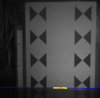
 This is the first time in years that I have taken a vacation to do just… nothing. Well, not nothing because I have made great progress on the reboot of GaugeCam–the camera based water level measurement system developed in conjunction with professors from NCSU and UNL. I think I am about halfway to the point where we will be able to start hosting water level cameras in the wild again. Today, I was able to implement some new methods to automatically find the water level by evaluating vertical swaths of the area between the bowtie targets shown in the image above. This is a really good, new thing in that the only thing necessary to set up the camera is to tell the system the x-y position of the individual bow ties in the system after the camera is mounted and pointed at the bow tie target. This is much easier than the previous system where it was necessary to follow an elaborate procedure to tell the system how and where to look for the water level. Hopefully, we will be able to publish a paper on how we do this that will help me in my PhD program if I ever get accepted and pull the trigger to do it. I am getting very much closer on all that and have hope it will happen.
Leave a Reply